Friday, July 15, 2016

The Hurricane Hunters

  Images courtesy of NOAA and Hurricane Hunters Association 
Hurricane Hunters are a breed of special individuals dedicated to inform the current strength of a tropical cyclone, location and direction over the open ocean. This team of individuals are primarily made up of pilots, navigator, meteorologist, technicians and a special aircraft to fly into the tropical cyclone. There are two teams of hurricane hunters one that fly out from Kessler Air Force Base in Mississippi, the 53d weather reconnaissance squadron using a WC-130J Hercules aircraft to penetrate the tropical cyclone and the other the NOAA Hurricane Hunters divided up into two aircrafts that fly out from MacDill Air Force Base in Tampa, Florida. NOAA uses the Lockheed WP-3D turboprop and the Gulfstream IV-SP jet for high altitude surveillance over and around the tropical cyclone. All of the weather observations taken from around, over and inside the tropical cyclone from the "Hurricane Hunters"are transmitted via satellite to the National Hurricane Center in Miami, Florida inorder to place Tropical Storm and Hurricane watches or warnings if needed also to better predict where the tropical cyclone may go. The information gathered by the "Hurricane Hunters" when flying into a tropical cyclone is essential in keeping the public safe and informed inorder to protect life and property.
See video on "Hurricane Hunters":https://youtu.be/JulJhamN7d8

Thursday, July 7, 2016

Steaming In July

July has gotten to ahead start with high temperatures in the lower 90's, overnight lows in the steaming low to mid 80's and heat indexes between 100 and 108 degrees fahrenheit with humidity levels reaching the 70% percentile range during mid afternoon hours causing excessive heat throughout the island chain. Please take every precaution while outdoors to beat the tropical heat, drink plenty of water, stay in the shade if possible and beware of any signs of heat exhaustion or heat stroke. See link:https://m.facebook.com/profile.php?ref=bookmarks#!/NWSMiami/photos/a.163531347035457.43818.161059913949267/1053505898037993/?type=3&source=48&refid=17&ref=bookmarks&_ft_=top_level_post_id.146874159068214%3Atl_objid.146874159068214%3Athid.100012368910112%3A306061129499414%3A2%3A0%3A1470034799%3A5768711688332367284&__tn__=E

Monday, June 27, 2016

June Weather Summary


The month of June is wrapping up to be a below normal precip month across the lower and middle Keys with deficits ranging between -2.65 inches at Key West and -2.66 inches at Marathon as of today June 27th 2016 unless any significant precip occurs during the next 3 days until the month ends, the month could certainly end below normal, precip wise for this June throughout the island chain. Also registering below normal precip amounts are the upper Keys with North Key Largo tallying in with 4.51 inches of precip so far this month and John Pennekamp State Park measuring 5.35 inches of precip for June so far. Temperature wise, near normal temps across the entire island chain will prevail. Average temps for June in Key West are 88 for a high and 79 for the low, Marathon 88 for a high and 78 for the low and the upper Keys 87 for a high and 77 for the low. Sea surface temperatures across the coastal waters of the island chain remain slightly above normal by 0.5-1.5 degrees fahrenheit. Daytime sea surface temperatures currently measuring between 86 and 89 degrees fahrenheit which should heat up even a little more until it peaks around in early September between a steamy 87 and 90 degree fahrenheit sea surface temperature that can make any ocean lover enjoy these fantastic conditions.

Sunday, June 19, 2016

Island Chain Land And Ocean Effects

   Images Courtesy NASA
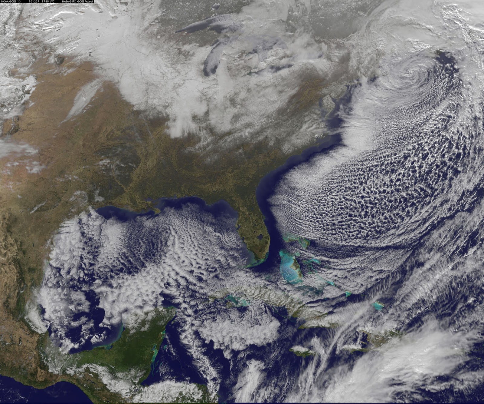
The Florida Keys island chain and its surrounding bodies of water affects its local weather in a particular way. For example, if we examine the geographical location of this archipelago compared to the Bahamian archipelago we can see a clear distinct geographical position of the Florida Keys island chain to the Bahamian island chain in that the archipelago of the Florida Keys lie on a semi latitudinal northeast to west-southwest position to the Bahamian archipelago that lie on a semi latitudinal northwest to southeast position. Keeping this in mind we can now examine the uniqueness that the Florida Keys weather has compared to the Bahamas. During winter, cold fronts push through the island chain advecting cooler air latitudinally over the Keys, causing temperatures to dip into the 50's and 60's and even sometimes into the 40's. As this cold air mass passes over the relatively warmer water that surrounds the chain of islands it becomes modified and increases the air temperature by at least 5 to 8 degrees warmer across the middle and lower keys compared to the South Florida mainland low temperatures. A shallow layer of stratocumulus clouds always tend to develop when a cold air mass passes over a relatively warmer surface in which the ocean is, therefore it holds a larger quantity of heat and is not affected by radiational cooling effects as the land is, meanwhile this stratocumulus deck that forms passes over the lower and middle keys and also helps contribute in keeping the air temperature a few degrees warmer than the coastal Miami mainland low temperatures in which their air temperature would not be influenced by the ocean or the stratocumulus deck because the cold air advection there would be coming from a north-northwest direction from mainland Florida.
    Images Courtesy NASA


The upper keys are usually not influenced by its surrounding waters to modify it's air temperature in these cold air outbreaks as the trajectory of the cold air advection is more aligned on a north-northwest position which limits the amount of coverage that the cold air mass passes over the surrounding waters of the upper keys therefore the temperature difference there is generally 1 to 3 degrees warmer compared to mainland Miami Dade coastal minimum temperatures. Considering that the same type of cold air mass that passes through the Florida Keys also passes through the western most Bahamas we would have a larger gradient of air temperatures between the Keys and the Bahamas for just two reasons. First, being that there is a larger amount of water between Florida and the northwestern Bahamian islands than from mainland South Florida to Key West therefore the cold air mass would traverse over a greater distance of water leading to a greater modification of the cold air mass on a same general latitudinal location of those two archipelagos. Finally, the last reason is the longitudinal effect of the cold air mass losing its cold dry air characteristics by becoming modified substantially as it traverses southeastward over the tropical maritime waters of the Atlantic Ocean and over the Bahamian chain of islands. Now let's observe the land effects of the Florida Keys upon its local weather during late spring and summer. A common daily weather phenomenon during this time of the year effects Keys weather, the so called "Cloud Lines" which form over the island chain during the early afternoon hours in conjunction with the diurnal heating taking place over the island chain, cumulus clouds develop parallel to the island chain or directly overhead maturing into cumulus congestus (towering cumulus clouds) and even sometimes into cumulonimbus clouds. As a result this microclimate phenomenon has an affect on daily rainfall, on Keys classic waterspout formations and lightning that forms from mature cumulonimbus. Please see links on Florida Keys cloud lines.http://www.srh.noaa.gov/key/?n=cloud_lines
Image Courtesy NWS Key West 
https://www.google.com.br/url?sa=t&source=web&rct=j&url=http://www.wdtb.noaa.gov/courses/winterawoc/microclimates/EYW/IC43e_Fuentes_Horvorka_EYW_20100331.pdf&ved=0ahUKEwi7vLGTyrTNAhVFIpAKHReZAbwQFggbMAA&usg=AFQjCNFoxAyIag6Ltact8eK8HSiZHXWuLw&sig2=RWsEscY0nUIr3sKNa_Ziew

Saturday, June 11, 2016

Saharan Dust In Tropical Paradise

Image Courtesy NASA
The Saharan dust storms that forms in the Saharan Desert of Africa traverses the entire length of the Atlantic Ocean in a 5,000 mile journey from the west coast of Africa westward to the Florida Keys, carried and suspended aloft into the atmosphere by the easterly trade winds. This weather related event occurs in the summer months from June through August causing scenic sunsets and hazy skies with a brownish appearance to it over the island chain. Persons with respitory problems should avoid outdoor activities during these Saharan dust events as it can aggravate or worsen those respitory symptoms. The Saharan dust has a negative effect on tropical cyclones by limiting the amount of tropical disturbances to form convection (showers and thunderstorms) that would initiate the beginning stages and ingredients inorder to develop tropical storms and hurricanes. Saharan dust is associated with dry stable air in the middle and upper layers of the atmosphere acting as an inhibiting factor (inversion layer) in developing cumulonimbus clouds that would normally require a substantial amount of moisture in those layers of the atmosphere for them to develop into mature thunderstorms and maintain the continuous process of thunderstorm genesis inorder for a tropical cyclone to mature and strengthen. On the otherhand these Saharan dust events make-up for some stunning sunset pictures that would make anybody come back to the Florida Keys during a Saharan dust event. See link on Saharan dust montoring.http://tropic.ssec.wisc.edu/real-time/salmain.php?&prod=splitE&time
    Image Courtesy NPS Dry Tortugas 


Thursday, June 9, 2016

Tropical Moisture Plume

A tropical moisture plume extending southwest from the Northwest Caribbean Sea, Central America and across the Florida Keys northeastward for several hundred miles over the Southwest Atlantic are associated with the tropical moisture plume that tropical storm Colin was once associated with when it was in the Caribbean Sea still as a tropical disturbance before moving northwestward and developing into a tropical storm in the southern Gulf of Mexico last week. This residual tropical moisture plume has resulted in producing quick moving showers and thunderstorms to move from the Florida Straits north northeastward across the island chain and out to sea. Precipitation amounts from these rapidly moving showers and thunderstorms vary from about a tenth of an inch (.10) up to over four tenths of an inch (+.40) throughout the island chain except in parts of Marathon Key where Curry Hammock State Park received 1.43 of rain likely from a training effect of showers and thunderstorms in that particular area of the middle keys. Otherwise this tropical moisture band should remain in place over the island chain approximately for one more day before dissipating and contributing to June's monthly rainfall for the Florida Keys.


Monday, June 6, 2016

Tropical Storm Colin

Tropical depression number 3 formed overs the southern Gulf of Mexico on June 5th 2016 while it intensified into Tropical Storm Colin later that afternoon. Colin is currently a 50 mph tropical cyclone, producing locally heavy rains over the Southeastern U.S and the Gulf Coast of Florida from the Big Bend of Florida down to the lower Florida Keys. Colin is a asymmetrical tropical storm with all of its inclement weather displaced well to the east and southeast of the center of low pressure. Colin has been experiencing moderate to strong southwesterly wind shear over the last 24 hours. Tropical storm wind gusts of 47 mph have already occurred over the gulf coastal waters of Key West this afternoon and rainfall amounts of up to a quarter of an inch (0.25) at Key West associated with a fast moving squall. Colin is expected to make landfall late tonight or early tomorrow morning over the Big Bend of Florida south of Apalachicola then rapidly move northeastward while skirting the Southeastern U.S coast by tomorrow and transitioning into an extratropical cyclone over the Atlantic Ocean.